
Red Rose Wilted
How Lancashire was carved up in the 1970s.

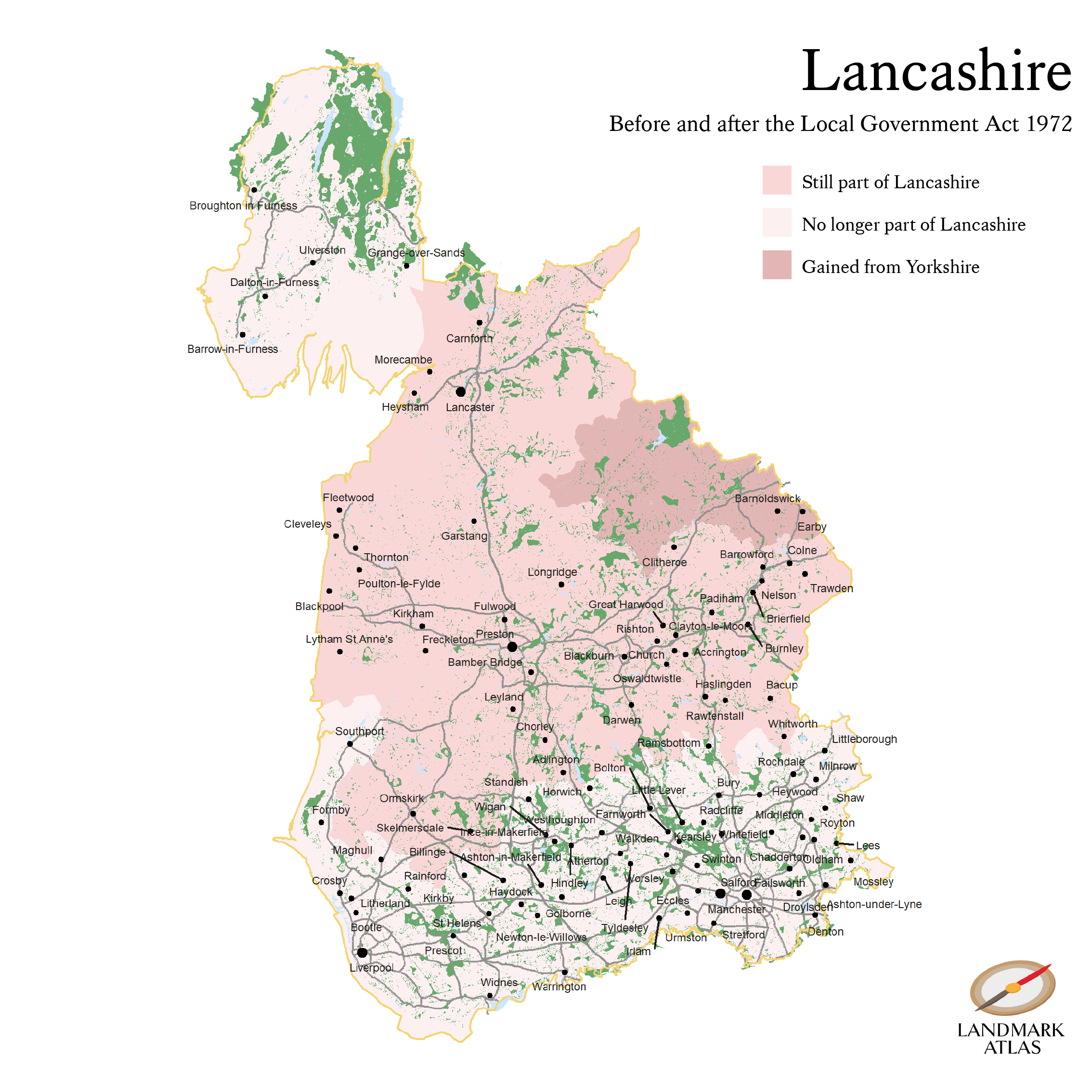
Lancashire is a shadow of its former self.
In 1971 the county was home to 5.12 million people. It was the most populous county in England outside of London.
The historic county of Lancashire was much larger than the ceremonial county is today. It stretched from Barrow-in-Furness in what is now Cumbria down to the River Mersey bordering Cheshire. It comprised more than 2,000 square miles of north west England, making it the fifth largest in the country by area.
In 2020 just 1.52m people lived in the ceremonial county of Lancashire, which only totalled 1,260 square miles of land.
The county had lost almost 40 per cent of its territory and 70 per cent of its population.
The map belows shows how Lancashire was reorganised from 1974:
How did this happen?
In short, the Local Government Act 1972. This was a significant piece of legislation that created the framework of local government that is still largely in effect in England today.
The Industrial Revolution had seen places such as Manchester and Birmingham emerge as major cities. Their conurbations spanned the traditional county boundaries that had been established hundreds of years earlier, posing problems for local administration.
The Act sought to remedy this by creating new metropolitan counties such as the West Midlands, Greater Manchester and West Yorkshire. It also shuffled around other strips of land here and there.
Lancashire gained a portion of largely rural land from the West Riding of Yorkshire which included the town of Barnoldswick. This swapping of the White Rose for the Red was controversial at the time (and remains so - watch these two ladies have a lively discussion about it on the BBC in 2019).
But the addition of this former Yorkshire territory was far outweighed by the loss of what became Greater Manchester and Merseyside.
These two counties are now home to 4.28m people and comprise 808 square miles of territory that would otherwise be in Lancashire.
The winners from the reorganisation
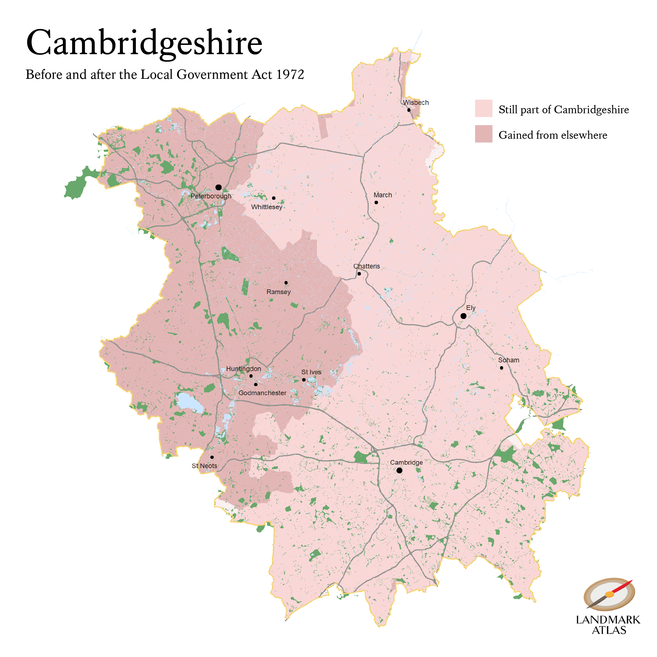
Even by British standards, local government pre-1974 in one corner of the East Midlands and the Fens was a curious business.
The Local Government Act 1888 created four small counties: the Isle of Ely, the Soke of Peterborough, Cambridgeshire and Huntingdonshire.
For various reasons these counties were considered lop-sided and too small to administer properly. In the 1960s the Isle of Ely was grouped with Cambridgeshire and the Soke of Peterborough with Huntingdonshire.
This decision too proved controversial. Sir Harry Legge-Bourke, MP for the Isle of Ely, said in a debate at the time that his constituents would rather continue as an independent council.
Rutland, another small nearby county, escaped this 1960s reorganisation. In the same debate, Sir Hamilton Kerr, MP for Cambridge, remarked on how the people of that small county (population in 1971: 27,471) fought to preserve its status:
The campaign of Rutland was so ingenious, so full-blooded, it filled me with admiration. At the county boundaries one was met with a forest of flags, every window carried a poster, every car a sticker carrying the same theme: "Rutland fights to keep local government local. Rutland fights on." Never since the days when Cromwell led his troops to Naseby have the leafy lanes and immemorial elms of Rutland witnessed such a scene.
In 1974 Cambridgeshire absorbed Huntingdonshire and Peterborough as well.
This means that Cambridgeshire is now 52 per cent larger than its traditional extent. In 1971 only 303,042 people lived in Cambridgeshire and the Isle of Ely. In 2020 a total of 859,830 lived in Cambridgeshire.
Conclusion
Fifty years on from the passing of the 1972 Act, Lancashire doesn’t have the same strength of regional identity as Yorkshire does. The legislation divided up Yorkshire as well but the pattern followed the older Ridings of Yorkshire reasonably closely.
Leeds, Bradford, Hull and the other cities in the county remain in parts of Yorkshire for administrative purposes, unlike Manchester and Liverpool.
Perhaps the separation of Liverpool and Manchester from Lancashire decreased the county’s sense of identity.
Perhaps this separation also contributed to the rivalry between Liverpool and Manchester that is familiar to those who live there and anyone who follows the Premier League.
Regardless, there are still plenty of people living in the towns scattered around those two great cities that consider themselves Lancastrians.
A recent poll by LancsLive found that 782 out of 1,016 of their readers thought Southport was in Lancashire rather than Merseyside.
As we approach the fiftieth anniversary of the 1972 Local Government Act taking effect, that sentiment shows little sign of vanishing.
Attribution statements:
Maps contain OS data © Crown copyright and database right 2022